![]()
![]()

We need your help! 🔥
Please consider disabling your ad-blocker to support this website! 🔑
We are a free, community-supported website! 🥰
We only display small unobtrusive ads which help us stay online! 💯
Thank you in advance! ❤️
We are a free, community-supported website! 🥰
We only display small unobtrusive ads which help us stay online! 💯
Thank you in advance! ❤️
Elk
ADDON. Version 2.2.2. Released on 2016-Feb-01. Provides 3 components. Created by Timothy Logan. Features 7 video tutorials.
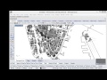
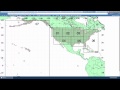
Elk is a set of tools to generate map and topographical surfaces using open source data from OpenStreetMap.org and USGS. OpenStretMap.org is an open/crowd sourced website of mapping data. It allows you to export XML formatted data of a selected area and then Elk will organize and construct collections of point and tag data so that you can begin creating curves and other Rhino/Grasshopper geometry. USGS is a science organization that provides access to a large range of scientific data pertaining to the earth. Elk uses data that originates from the Shuttle Radar Topography Mission (SRTM) of 2000. This was a shuttle mission where most of the earth was scanned for elevation and packaged in 1°x1° tiles.
Elk2
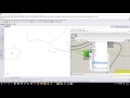
| Location (Loc) OpenStreetMap and Topograhy | |
| OSM Data (OSM) Get Point and Tag data from an OSM file. | |
| Topography (Topo) Generate Topography surfaces from USGS IMG Raster files or from SRTM HGT files. |


Site design © Robin Rodricks.
Elk and associated data © 2025 Timothy Logan.
Rhinoceros and Grasshopper are registered trademarks of Robert McNeel & Associates.
Hosted by GitHub