![]()
![]()

We need your help! 🔥
Please consider disabling your ad-blocker to support this website! 🔑
We are a free, community-supported website! 🥰
We only display small unobtrusive ads which help us stay online! 💯
Thank you in advance! ❤️
We are a free, community-supported website! 🥰
We only display small unobtrusive ads which help us stay online! 💯
Thank you in advance! ❤️
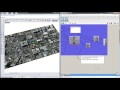
GdalTranslate
Manipulate raster data with the GDAL Translate program given a source dataset, a destination dataset and a list of options. Formatting for the list of options should be a single string of text with a space separating each term where '-' should preceed the option parameter and the next item in the list should be that parameter's value. For instance, to convert raster data to PNG format the options string would be '-of PNG'. To clip a large raster data set to a boundary of upper left x (ulx), upper left y (uly), lower right x (lrx) and lower right y (lry), the options string would be '-projwin ulx uly lrx lry' where ulx, uly, lrx and lry are substituted with coordinate values. More information about translate options can be found at https://gdal.org/programs/gdal_translate.html.
Inputs
| Name | ID | Description | Type |
|---|---|---|---|
| Source dataset | source | File location for the source raster dataset. | Text |
| Destination dataset | dest | File location for the destination dataset. | Text |
| Options | options | String of options with a space separating each term. For instance, to convert raster data to PNG format the options string would be '-of PNG'. | Text |
Outputs
| Name | ID | Description | Type |
|---|---|---|---|
| Source Info | sourceInfo | List of information about the source dataset. | Text |
| Destination Info | destInfo | List of information about the destination dataset. | Text |
| Destination File | destFile | File location of destination datasource. | Text |

Site design © Robin Rodricks.
Heron and associated data © 2025 Brian Washburn.
Rhinoceros and Grasshopper are registered trademarks of Robert McNeel & Associates.
Hosted by GitHub