![]()
![]()

We need your help! 🔥
Please consider disabling your ad-blocker to support this website! 🔑
We are a free, community-supported website! 🥰
We only display small unobtrusive ads which help us stay online! 💯
Thank you in advance! ❤️
We are a free, community-supported website! 🥰
We only display small unobtrusive ads which help us stay online! 💯
Thank you in advance! ❤️
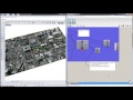
Mapbox Isochrone
The Mapbox Isochrone API allows you to request polygon features that show areas which are reachable within a specified amount of time from a location. The API calculates isochrones up to 60 minutes using driving, cycling, or walking profiles.
Inputs
| Name | ID | Description | Type |
|---|---|---|---|
| Location | location | Location around which to center the isochrone lines. | Point |
| Contour | contour | The time, in minutes, or distance to use for the isochrone contour. Specify which type to use in the component menu.The maximum time that can be specified is 60 minutes. The maximum distance that can be specified is Rhino unit equivalent of 100,000 meters (100km). | Number |
| Denoise | denoise | A positive floating point from 0.0 to 1.0 that can be used to remove smaller contours. The default is 0.25. A value of 1.0 will only return the largest contour for a given value. A value of 0.5 drops any contours that are less than half the area of the largest contour in the set of contours for that same value. | Number |
| Generalize | generalize | A positive floating point value, in meters, used as the tolerance for Douglas-Peucker generalization. There is no upper bound. If no value is specified in the request, the Isochrone API will choose the most optimized generalization to use for the request. Note that the generalization of contours can lead to self-intersections, as well as intersections of adjacent contours. | Number |
| Mapbox Access Token | mbToken | Mapbox Access Token string for access to Mapbox resources. Or set an Environment Variable 'HERONMAPOXTOKEN' with your token as the string. | Text |
| Run | get | Go ahead and get isochrones from the service | Boolean |
Outputs
| Name | ID | Description | Type |
|---|---|---|---|
| Isochrone | Isochrone | The Mapbox-generated Isochrone from a given point | Geometry |
| URL | Url | URL queried | Text |
| Mapbox Attribution | mbAtt | Mapbox word mark and text attribution required by Mapbox | Text |

Site design © Robin Rodricks.
Heron and associated data © 2025 Brian Washburn.
Rhinoceros and Grasshopper are registered trademarks of Robert McNeel & Associates.
Hosted by GitHub