![]()
![]()

We need your help! 🔥
Please consider disabling your ad-blocker to support this website! 🔑
We are a free, community-supported website! 🥰
We only display small unobtrusive ads which help us stay online! 💯
Thank you in advance! ❤️
We are a free, community-supported website! 🥰
We only display small unobtrusive ads which help us stay online! 💯
Thank you in advance! ❤️
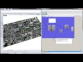
Get REST Raster
Get raster imagery from ArcGIS REST Services. Use the SetSRS component to set the spatial reference system used by this component.
Inputs
| Name | ID | Description | Type |
|---|---|---|---|
| Boundary | boundary | Boundary curve(s) for imagery | Curve |
| Resolution | resolution | Maximum resolution for images | Integer |
| Target Folder | folderPath | Folder to save image files | Text |
| Prefix | prefix | Prefix for image file name | Text |
| REST URL | URL | ArcGIS REST Service website to query. Use the component menu item "Create REST Raster Source List" for some examples. | Text |
| Image Type | imageType | Image file type to download from the service. Some REST raster services have a range of available types including jpg, tif, png, png32, svg. | Text |
| Run | run | Go ahead and download imagery from the Service | Boolean |
Outputs
| Name | ID | Description | Type |
|---|---|---|---|
| Image | Image | File location of downloaded image | Text |
| Image Frame | imageFrame | Bounding box of image for mapping to geometry | Curve |
| REST Query | RESTQuery | Full text of REST query | Text |

Site design © Robin Rodricks.
Heron and associated data © 2025 Brian Washburn.
Rhinoceros and Grasshopper are registered trademarks of Robert McNeel & Associates.
Hosted by GitHub