![]()
![]()

We need your help! 🔥
Please consider disabling your ad-blocker to support this website! 🔑
We are a free, community-supported website! 🥰
We only display small unobtrusive ads which help us stay online! 💯
Thank you in advance! ❤️
We are a free, community-supported website! 🥰
We only display small unobtrusive ads which help us stay online! 💯
Thank you in advance! ❤️
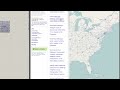
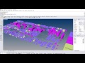
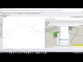
Topography
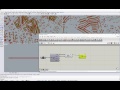
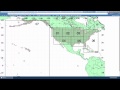
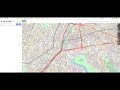
Generate Topography surfaces from USGS IMG Raster files or from SRTM HGT files.
Inputs
| Name | ID | Description | Type |
|---|---|---|---|
| File Path | File | Path to an HGT, GeoTiff, or IMG file | Text |
| Longitude | Lon | Longitiude domain. | Domain |
| Latitude | Lat | Latitiude domain. | Domain |
Outputs
| Name | ID | Description | Type |
|---|---|---|---|
| File Info | Info | File info related to bounding box domain | Text |
| Points | Pts | Points, branched along longitude | Point |
| Curves | Crvs | Curves representing the longitudinal lines | Curve |
| Surface | Srf | Topo surface genreated from the curves. | Surface |
Site design © Robin Rodricks.
Elk and associated data © 2025 Timothy Logan.
Rhinoceros and Grasshopper are registered trademarks of Robert McNeel & Associates.
Hosted by GitHub