![]()
![]()

We need your help! 🔥
Please consider disabling your ad-blocker to support this website! 🔑
We are a free, community-supported website! 🥰
We only display small unobtrusive ads which help us stay online! 💯
Thank you in advance! ❤️
We are a free, community-supported website! 🥰
We only display small unobtrusive ads which help us stay online! 💯
Thank you in advance! ❤️
Heron
ADDON. Version 0.4.2. Released on 26-Nov-2023. Provides 50 components. Created by Brian Washburn. Features 4 video tutorials.
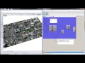
Heron enables the import of GIS data from various sources into the Rhino/Grasshopper environment, located, scaled and cropped based on an Earth Anchor Point and a clipping polygon. Sources of GIS data include Shapefiles, USGS IMG/HGT Elevation files and ArcGIS REST Services over the web.
Utilities
| Multi SDiff (MSDiff) This multithreaded boolean solid difference (SDiff) component spreads the branches of input over threads for the boolean operation | |
| GDAL Details (GD) This component enumerates the current version of GDAL and it's available raster and vector drivers. | |
| Topiary Flatten (TF) Flatten branches by a set depth from the deepest path in a data tree. The resulting tree will look more like a topiary. This can be useful for data trees with uneven path depths. | |
| Hex to Color (H2C) Convert a hexidecimal color to RGBA format. | |
| Color to Hex (C2H) Convert an RGBA color to hexidecimal format. | |
| Image Filtered Colors (ImageFC) Get a filtered pixel count of colors contained in an image based on color list. | |
| Cubemap From View Plus (CM+) Generate a cubemap from a given plane using the specified display mode. This component is also able to visualize ray casting based on colors in the cubemap. | |
| Cubemap From View (CM) Generate a cubemap from a given plane using the specified display mode. | |
| Cubemap To Equirectangular (CubeToEqui) Convert a cube map panorama to an equirectangular panorama. | |
| Image Top Colors (ImageTC) Get a sorted list of the top colors contained in an image. | |
| Rotate Image (RotateImage) Roate an image 90, 180 or 270 degrees. | |
| Flip Image (FlipImage) Flip an image along its vertical, horizontal axis or both. | |
| Multi Mesh Patch (MMPatch) Multithreaded creation of mesh patches from planar polylines | |
| Visual Center (VC) Find the visual center of closed planar curves. The resulting point will lie within the boundary of the curve and multiple curves on a branch will be treated as a surface with holes. | |
| Multi Move to Topo (MMoveToTopo) Move breps, surfaces, meshes, polylines and points to a topography mesh |
GIS Tools
| DMStoDD (DMS to DD) Convert Latitude and Longitude coordinates formatted in Degree Mintue Seconds (DMS) to Decimal Degree (DD) format | |
| Gdal Fill No Data (GFND) Fill raster regions that have no data by interpolation from edges with the GDAL FillNoData program. More information can be found at https://gdal.org/programs/gdal_fillnodata.html. | |
| Gdal Info (GI) Gdalinfo program lists various information about a GDAL supported raster dataset. More information about Gdalinfo options can be found at https://gdal.org/programs/gdalinfo.html. | |
| Set EarthAnchorPoint (SetEAP) Set the Rhino EarthAnchorPoint using either an address or Lat/Lon coordinates | |
| Set Spatial Reference System (SRS) Set the spatial reference system to be used by Heron SRS-enabled components | |
| GdalOgr2Ogr Manipulate vector data with the GDAL OGR2OGR program given a source dataset, a destination dataset and a list of options | |
| GdalWarp Manipulate raster data with the GDAL Warp program given a source dataset, a destination dataset and a list of options | |
| GdalTranslate Manipulate raster data with the GDAL Translate program given a source dataset, a destination dataset and a list of options | |
| Decimal Degrees to XY (DDtoXY) Convert WGS84 Decimal Degrees Longitude/Latitude to X/Y | |
| Coordinate Transformation (CT) Transform points from a source SRS to a destination SRS. The source points should be in the coordinate system of the source SRS. | |
| XY to Decimal Degrees (XYtoDD) Convert X/Y to Decimal Degrees Longitude/Latitude in the WGS84 spatial reference system | |
| Gdal Convex Hull (GCVH) Create a convex hull around geometry using Gdal's convex hull function. GDAL convex hull only works in 2D, so the results will be on the XY plane. | |
| Gdal Buffer (GdalBuffer) Create a buffer around a geometry using Gdal's buffer function. GDAL buffering only works in 2D, so the results will be on the XY plane. |
GIS API
| Mapbox Isochrone (MapboxIsochrone) The Mapbox Isochrone API allows you to request polygon features that show areas which are reachable within a specified amount of time from a location | |
| Yelp Search business on Yelp. | |
| Mapbox Raster (MapboxRaster) Get raster imagery from a Mapbox service. Requires a Mapbox Token. | |
| Mapbox Topography (MapboxTopo) Get mesh topography from a Mapbox service. Requires a Mapbox Token. | |
| Mapbox Vector (MapboxVector) Get vector data from a Mapbox service. Requires a Mapbox Token. | |
| Slippy Raster Get raster imagery from a tile-based map service. Use the component menu to select the service. | |
| Slippy Tiles (SlippyTiles) Visualize boundaries of slippy map tiles within a given boundary at a given zoom level. See https://en.wikipedia.org/wiki/Tiled_web_map for more information about map tiles. | |
| Slippy Viewport (SlippyVP) Projects the boundary of a given Viewport to the World XY plane and calculates a good Zoom level for use with tile-based map components. |
GIS Import | Export
| Import Vector Lite (IVL) This is a basic version of the Import Vector component allowing the import of GIS data, including SHP, GeoJSON, OSM, KML, MVT and GDB folders | |
| Import Vector (IV) Import vector GIS data clipped to a boundary, including SHP, GeoJSON, OSM, KML, MVT and GDB folders. Use the SetSRS component to set the spatial reference system used by this component. | |
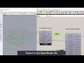
| Export Vector (ExportVector) Export Grasshopper geometry to Shapefile, GeoJSON, KML and GML file formats in the WGS84 (EPSG:4326) spatial reference system | |
| Import LAZ (ImportLAZ) Import LAS & LAZ files. | |
| Import OSM (ImportOSM) Import vector OpenStreetMap data clipped to a boundary. Nodes, Ways and Relations are organized onto their own branches in the output. | |
| Import Raster (ImportRaster) Import georeferenced raster data. | |
| Import Topo (ImportTopo) Create a topographic mesh from a raster file (IMG, HGT, ASCII, DEM, TIF, etc) clipped to a boundary |
GIS REST
| Get REST Raster (RESTRaster) Get raster imagery from ArcGIS REST Services. Use the SetSRS component to set the spatial reference system used by this component. | |
| Get REST Vector (RESTVector) Get vector data from ArcGIS REST Services | |
| Get REST Service Layers (RESTLayer) Discover ArcGIS REST Service Layers | |
| Get REST OSM (OSMRest) Get an OSM vector file within a boundary from web services such as the Overpass API. Use a search term to filter results and increase speed. | |
| ESRI REST Service Reverse Geocode (RESTRevGeo) Get the closest addresses to XY coordinates using the ESRI reverse geocode service. | |
| Get REST Topography (RESTTopo) Get STRM, ALOS, GMRT and USGS topographic data from web services | |
| ESRI REST Service Geocode (RESTGeocode) Get coordinates based on a Point-of-Interest or Address using the ESRI geocode service. |

Site design © Robin Rodricks.
Heron and associated data © 2025 Brian Washburn.
Rhinoceros and Grasshopper are registered trademarks of Robert McNeel & Associates.
Hosted by GitHub