![]()
![]()

We need your help! 🔥
Please consider disabling your ad-blocker to support this website! 🔑
We are a free, community-supported website! 🥰
We only display small unobtrusive ads which help us stay online! 💯
Thank you in advance! ❤️
We are a free, community-supported website! 🥰
We only display small unobtrusive ads which help us stay online! 💯
Thank you in advance! ❤️
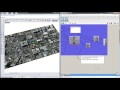
Slippy Tiles
Visualize boundaries of slippy map tiles within a given boundary at a given zoom level. See https://en.wikipedia.org/wiki/Tiled_web_map for more information about map tiles.
Inputs
| Name | ID | Description | Type |
|---|---|---|---|
| Boundary | boundary | Boundary curve for map tiles | Curve |
| Zoom Level | zoom | Slippy map zoom level. Higher zoom level is higher resolution. | Integer |
Outputs
| Name | ID | Description | Type |
|---|---|---|---|
| Tile Extents | tiles | Map tile boundaries for each tile | Curve |
| Tile ID | id | Map tile ID. The tile ID is formatted 'Z-X-Y' where Z is zoom level, X is the column and Y the row. | Text |

Site design © Robin Rodricks.
Heron and associated data © 2025 Brian Washburn.
Rhinoceros and Grasshopper are registered trademarks of Robert McNeel & Associates.
Hosted by GitHub