![]()
![]()

We need your help! 🔥
Please consider disabling your ad-blocker to support this website! 🔑
We are a free, community-supported website! 🥰
We only display small unobtrusive ads which help us stay online! 💯
Thank you in advance! ❤️
We are a free, community-supported website! 🥰
We only display small unobtrusive ads which help us stay online! 💯
Thank you in advance! ❤️
Export Vector
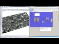
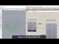
Export Grasshopper geometry to Shapefile, GeoJSON, KML and GML file formats in the WGS84 (EPSG:4326) spatial reference system. Inputs should adhere to the Simple Features Data Model where each feature, containing point(s), polyline(s), mesh(es) or a combination of these has data values for each field. Note exporting multiple goemetry types on the same branch (a geometry collection) may cause a shapefile export to fail.
Inputs
| Name | ID | Description | Type |
|---|---|---|---|
| Vector Data Filename | filename | File name to give the vector data ouput. Do not include file extension. | Text |
| Vector Data Folder | folder | Folder location to save the vector data ouput | Text |
| Fields | fields | Fields of data associated with the vector data features. For KML exports, consider adding an 'altitudeMode' field with possible values of 'relativeToGround' or 'absolute' and an 'OGR_STYLE' field to control color and transparency via hexidicemal values (see ColorToHex component). | Text |
| Values | values | Field values for each feature | Text |
| Feature Geometry | featureGeomery | Geometry contained in the feature. Geometry can be point(s), polyline(s), mesh(es) or a combination of these. | Geometry |
| Export | export | Go ahead and export feature geometry with associated fields and values to the specified location. Existing files will be overwritten. | Boolean |
Outputs
| Name | ID | Description | Type |
|---|---|---|---|
| Vector Data Location | filePath | File path location of saved vector data | Text |
Site design © Robin Rodricks.
Heron and associated data © 2025 Brian Washburn.
Rhinoceros and Grasshopper are registered trademarks of Robert McNeel & Associates.
Hosted by GitHub