![]()
![]()

We need your help! 🔥
Please consider disabling your ad-blocker to support this website! 🔑
We are a free, community-supported website! 🥰
We only display small unobtrusive ads which help us stay online! 💯
Thank you in advance! ❤️
We are a free, community-supported website! 🥰
We only display small unobtrusive ads which help us stay online! 💯
Thank you in advance! ❤️
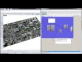
Import OSM
Import vector OpenStreetMap data clipped to a boundary. Nodes, Ways and Relations are organized onto their own branches in the output.
Inputs
| Name | ID | Description | Type |
|---|---|---|---|
| Boundary | boundary | Boundary curve for vector data | Curve |
| OSM Data Location | filePath | File path for the OSM vector data input | Text |
| Filter Fields | filterFields | List of filter terms for OSM fields such as highway, route, building, etc. | Text |
| Filter Field,Value | filterFieldValue | List of filter terms for OSM fields and values. Format Field,Value like 'addr:street,Main.' | Text |
Outputs
| Name | ID | Description | Type |
|---|---|---|---|
| Extents | extents | Bounding box generated from 'bounds' in OSM file if present. | Curve |
| Fields | fields | Fields of data associated with the vector data features | Text |
| Values | values | Field values for each feature | Text |
| Feature Geometry | featureGeomery | Geometry contained in the feature | Geometry |
| Buildings | buildings | Building geometry given ways or relations with a 'building' or 'building:part' tag. | Geometry |

Site design © Robin Rodricks.
Heron and associated data © 2025 Brian Washburn.
Rhinoceros and Grasshopper are registered trademarks of Robert McNeel & Associates.
Hosted by GitHub