![]()
![]()

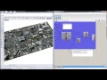
Import SHP
Import a Shapefile clipped to a boundary
Inputs
| Name | ID | Description | Type |
|---|---|---|---|
| Boundary | boundary | Boundary curve(s) for vector data | Curve |
| Shapefile Location | shpLocation | Filepath for the *.shp input | Text |
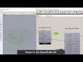
Outputs
| Name | ID | Description | Type |
|---|---|---|---|
| LayerName | layerName | Shapefile Layer Name | Text |
| shpFeatureCount | shpFeatureCount | Total number of features in the Shapefile | Integer |
| shpExtent | shpExtent | Bounding box of all Shapefile features | Curve |
| shpSpatRef | shpSpatRef | Spatial Reference of the input Shapefile | Text |
| Fields | fields | Fields of data associated with the Shapefile features | Text |
| Values | values | Field values for each feature | Text |
| FeaturePoints | featurePoints | Point geometry describing each feature | Point |
Site design © Robin Rodricks.
Heron and associated data © 2023 Brian Washburn.
Rhinoceros and Grasshopper are registered trademarks of Robert McNeel & Associates.
Hosted by GitHub